|
THE FAIRFORD BRANCH LINE |
|
|
|
ALVESCOT |
|
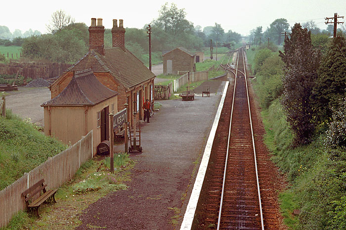
Alvescot station (13 miles 74 chains from Yarnton) was a single platform station with a goods loop and siding. The station building was of a standard EGR design, although it
differed from all the others in being built of brick, rather than the local stone. Apart from a couple of small stores and two ground frames, the only other building on the site was a weighbridge hut. The site can be
viewed today from the adjacent road bridge (SP278042), although scattered machinery and a coal yard is all that is now visible. |
|
|
|
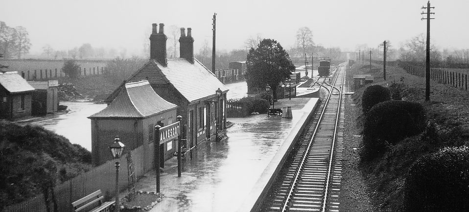
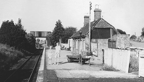
A rain soaked Alvescot station in 1934. An interesting comparison with the picture below, which was taken from almost the same viewpoint over a quarter of a century later.
Although the trackwork and buildings remained unchanged, subtle differences can be seen. Pre-war the standards of maintenance were obviously higher, as stone edged flower beds and neatly trimmed bushes give the station a
well cared for appearance. Note also, that in 1934 the station still had platform lighting. This view also shows the weighbridge hut on the extreme left, which was the last building to survive on the site.
Martin Loader Collection |
|
|
|
Alvescot station viewed from the road bridge in the early 1960s. Colour pictures of Alvescot seem particularly rare, and this picture is therefore especially important as it
shows the red brick construction of the station building. Why Alvescot was built of red brick, when the other four EGR station buildings were built of the local Cotswold stone has never been satisfactorily explained. This
picture also gives an excellent view of the small goods yard. On the original Kodachrome slide the ground frame and PW hut are clearly visible. as is the farm track bridge in the background. Compare this view with the same
scene on 6 December 2005 (hover your mouse over the image). The only real indication that this is the same view is the tree in the background, which seems to have grown surprisingly little in the intervening years!
Colour Rail & Martin Loader Past and Present Photo
|
 |
|
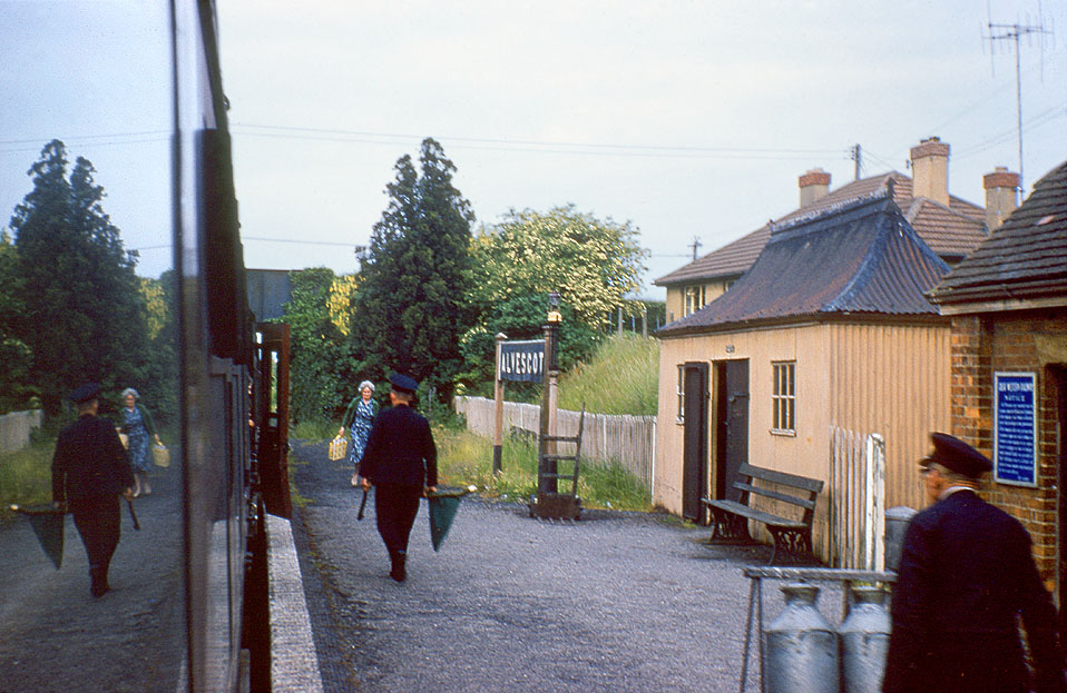
More staff than passengers? Probably not on this occasion, as this picture is taken during the last weeks of the line's operation. This is a charming view from the train,
with a well caught reflection in the coach's window. There is plenty of Great Western Railway infrastructure in view, including the pagoda hut, platform seat, and blue enamel notice.
Martin Loader Collection
|
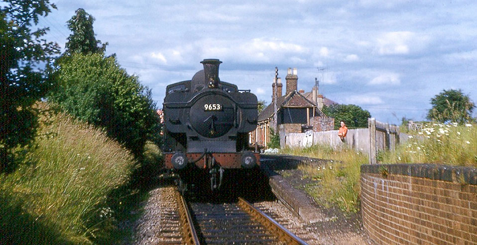 |
57xx 0-6-0PT 9653 stands at Alvescot station in June 1962. Although the grass is already taking over the platform and the top of the end loading dock in the foreground, the
track is still in pristine condition.
John Strange |
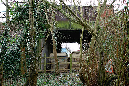
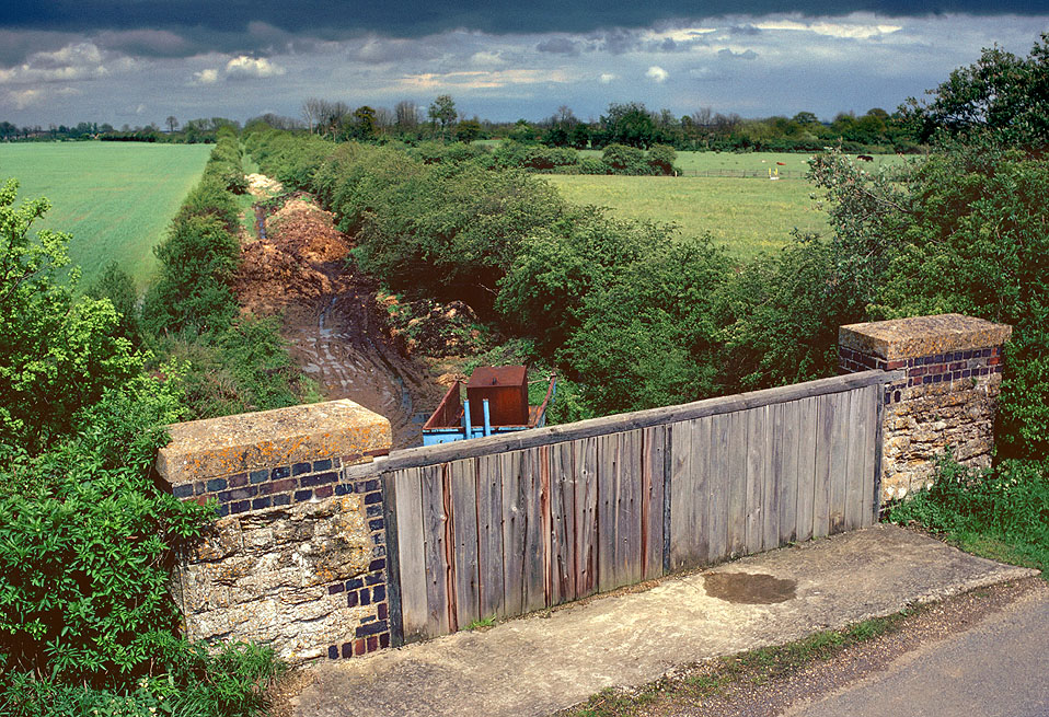
The road bridge at Alvescot still survives, and as it is less humpbacked than some of the others and was strengthened during the line's later years, it is likely to remain in place for the
foreseeable future. Although clear on the station side (see above), the other side has now become very overgrown, with trees and dense scrub. This view on 24 February 2008 shows the eastern face of the bridge, with the
abutments and wing walls covered in ivy.
Martin Loader |
|
 |
The road overbridge can clearly be seen in this 20 August 1961 view, looking back towards Carterton. Note the track curving to the right, preceded by a slight reverse curve,
which is not readily apparent from the official track plans. The open roofed lavatory extension is nearest the camera, complete with crumbling notice board on the platform side. Indeed, over a year before closure, the
whole station already has an air of semi abandonment. The gates visible on the extreme right were probably only closed once a year, a job which my grandfather as local policeman had to oversee in order to prevent the
station becoming a public right of way.
Martin Loader Collection
|
|
|
|
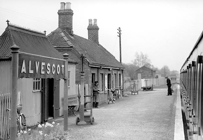
Alvescot station pictured on 17 April 1959. This view clearly shows the brick construction of the station building. Plenty of detail of a typical Great Western branch line
station is also visible, from the GWR seat and pagoda hut to the platform trolleys and barrows. More homely touches such as the daffodils growing under the station nameboard, and the bicycles leaning against the station
building and fence reinforce the easy going nature of the line. In the background can be seen the small goods store and yard crane. A sixteen ton steel open wagon can also be seen standing on the goods loop, while a wooden
bodied open wagon can just be glimpsed on the back siding, behind the shed.
Martin Loader Collection |
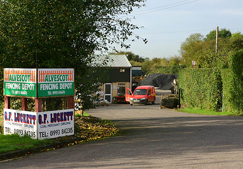 |
The entrance to the site of Alvescot station on 27 October 2006. The postman delivers to the businesses still operating from the site, which includes G. F. Luckett, coal
merchant. The heaps of coal visible behind the Royal Mail van indicate that even if most other domestic coal merchants have ceased trading, Luckett's business continues to thrive. It is ironic that long after the closure
of the line this coal business continues to operate from the same site, thus providing a link with the steam age and providing over a century's continuous coal trading on the site.
Martin Loader |
|
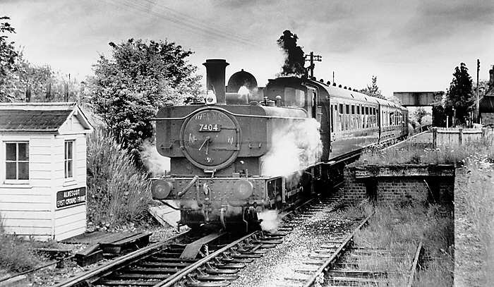
74xx Class 0-6-0PT 7404 pulls away from Alvescot with an Oxford to Fairford service in June 1962. The wooden hut on the left is Alvescot East Ground Frame, a similar hut was
provided at the far end of the goods loop. The loco is just approaching the point that leads to the goods loop. Weeds are already taking over the little used end loading bay, and complete closure is only days away.
Gerald T. Robinson
|
|
|
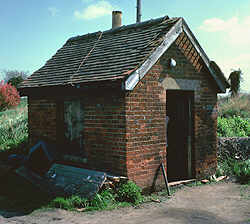
The last surviving building at Alvescot was the tiny weighbridge hut, which was in use as J. F. Luckett's coal yard office when photographed on 19 April 1980. Subsequently a
large workshop was built on this site. Although the railway has long gone, the yard carries on its former use as a coal yard, as indeed did many such yards on former branch lines.
Martin Loader |
|
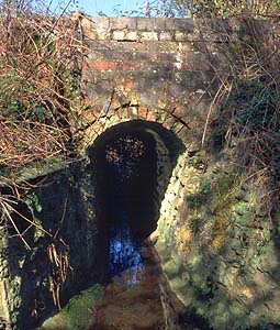
Clanfield Brook is a small stream that rises in a series of springs to the west of Alvescot and then travels south to join the Thames via the Sharney and Burroway Brooks (part
of the network of streams in the Thames flood plain). It passes under the Fairford Branch just to the west of Alvescot station (SP273037). It is pictured here on 28 February 2004, with the 3 ft brick arch on top of the
stone abutments (as listed in the GWR bridge register) still in good condition.
Martin Loader
|
|
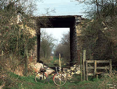 |
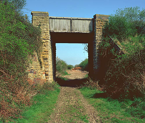
Out of the fifteen East Gloucestershire Railway road overbridges, three were demolished soon after the railway closed (Ducklington Lane at Witney, Curbridge & Fairford),
while the Witney station bridge followed in the 1980s. One other only survives in part: the bridge on the bridleway between Alvescot and Calcroft Lane (SP270035) was partly demolished in 1991, the parapets being removed and
the void filled with hardcore. This 31 March 1991 view looking towards Alvescot (with my bike included for scale!) shows the work in progress. Behind the bike are the remains of the parapets which have simply been pushed
over onto the trackbed. Today the buried remains of the 12 ft 9 in wide bridge are indicated by a large mound.
Martin Loader
|
|
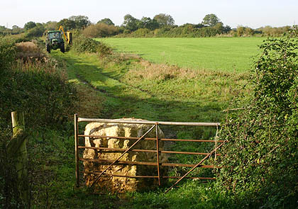
This view is looking south-west from the site of the bridge near Alvescot on 27 October 2006. It is taken from the slope that now connects the top of the bridge with the
trackbed. In fact, as can be seen from the picture above, a considerable quantity of material was required to fill the area where my bike was. After all that trouble to create a graded incline, a large block of concrete
now blocks the end of the slope. In the distance a tractor can be seen on the course of the line trimming the rather intermittent hedge along the former railway boundary.
Martin Loader |
|
|
|
Calcroft Lane Bridge (SP261026) was like a lot of the overbridges on the branch, built slightly on the skew (in this case giving measurements of 12ft 8 in square and 13 ft on
the skew). This can be seen in the view looking north-east on 19 April 1980. This bridge still survives and barring any major landslip in the poorly built approach roads, will probably escape the attentions of the highways
authority, as Calcroft Lane is a little used narrow road linking Broadwell to Clanfield. It is in a poor state of repair and has recently had signs erected at either end describing it as a 'failed road'. Council signs are a
little vague, as it is also signed up as a gated road, something it hasn't been in my lifetime!
Martin Loader
|
|
|
|
By standing on the opposite parapet (don't step back!) it was possible to get this view of the Calcroft Lane bridge on 27 May 1979. As can be seen, the track towards
Alvescot has been taken over by the local farmer. Note the original wooden parapet which has since been replaced. As with other EGR bridges an often random mixture of local Cotswold stone and blue engineer's bricks can
be seen. Although offering a good vantage point, particularly in the opposite direction, I have never seen a picture taken from this bridge of the line in operation.
Martin Loader |
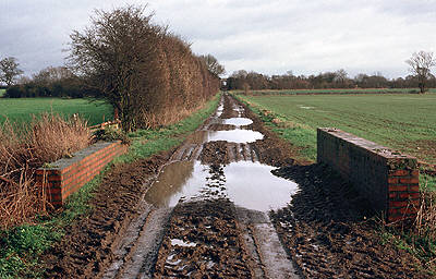 |
A short distance from the Calcroft Lane bridge, the line crossed two streams in quick succession: the Langhat Ditch (SP260025) and the larger Broadwell Brook (SP259024). This 30
January 1988 view is looking back towards the Calcroft Lane bridge, with the Broadwell Brook bridge in the foreground. The course of the Langhat Ditch can just be seen crossing the field on the right. This section of the
trackbed is now a public right of way.
Martin Loader
|
|
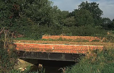
By 18 September 1993, a few courses of brickwork had been removed to allow the passage of larger farm machinery which makes extensive use of the old trackbed at this point. This
obviously proved inadequate, as by 2003 three more courses had been removed! This side view
illustrates well the construction of the bridge, with large steel beams providing support for the track. However just visible
in the water is one of several timber piles - these are the remnants of the former bridge, which was of three spans (6 ft 9 in, 9 ft 9 in & 7 ft 3 in). This was replaced in November 1905 by the present structure at a
cost of £75.
Martin Loader
|
 |
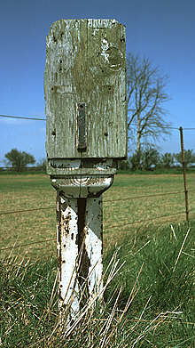 |
Standard Great Western Railway mileposts were provided on the Fairford Branch, those on the Witney to Fairford section did not receive the later BR yellow paint scheme. The last
remnants of white paint can be seen here on milepost 83¼ situated between the Calcroft Lane bridge and Kelmscott & Langford station. Although the position of the metal 83 numerals can barely be made out, the position of
the horizontal divider is clear and the single digit indicating the quarter mile is still attached. Not too bad, as when this picture was taken on 19 April 1980, the line had been closed for over 17 years. Since then
however, the wooded head has disappeared in common with virtually all the posts on the line. The mileage of course refers to the buffer stops at Paddington station in London.
Martin Loader
|
|